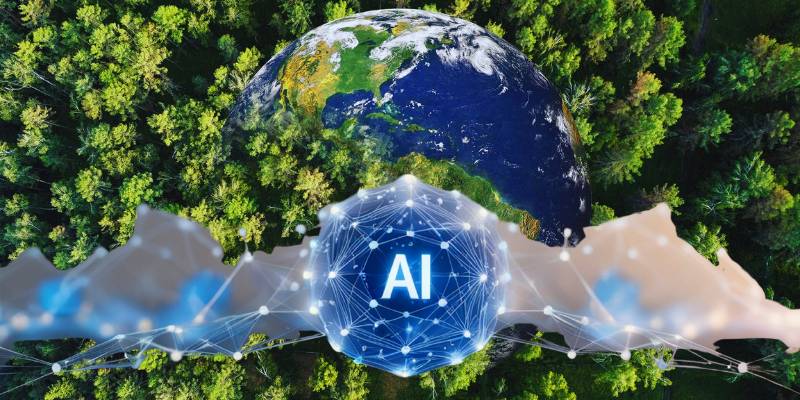
Forests typically only hit the headlines when something has gone wrong. A forest fire is raging out of control. A tree has fallen. Yet another tract of tropical forest has been clear-cut. But in the background, out of sight, there have been some extraordinary developments in the past few years in how forests are monitored and managed.
Activities that once took months to detect and report through field-based observation and analysis can now be picked up by satellites in a matter of days, or even minutes.
It’s a curious blend of space-age technology and boots-on-the-ground conservation: An algorithm churns away on a satellite image, while a ranger trudges through the mud to confirm what is actually going on. The objective is straightforward even if the technology isn’t: to understand what is happening to the world’s forests quickly enough to do something about it.
When you step back and look at the big picture, the story of forest monitoring in the modern
Global Deforestation Statistics (2023–2025): What the Data Really Shows
The evolution of forest monitoring is quite a story. It used to involve people on the ground, with clipboards and boots. A worthy endeavor, yes, but also agonizingly slow. By the time a ranger could confirm illegal logging in some remote area, the loggers were long gone. But artificial intelligence has slowly been creeping into the picture.
Today, an almost incessant stream of satellites and A.I. systems are analyzing forests for subtle patterns that humans couldn’t possibly identify in time. The upshot is forest monitoring in near real time. According to the World Resources Institute’s Global Forest Watch platform, A.I. satellite alerts detected more than 9.7 million deforestation alerts globally in 2024 alone. That’s right, millions.
Each alert represents a possible disturbance detected through satellite analysis. The cadence of monitoring is changing. A decade ago, forest loss reports could lag by months. Algorithms now detect changes in days, or even hours. And, to be honest, that change seems a bit like the leap from homing pigeon to live video.
Why satellites needed A.I.
Satellites have been observing the Earth for decades. NASA’s Landsat program has been gathering images since the 1970s. The problem wasn’t that there was too little data. There was too much. Each Landsat satellite captures hundreds of images a day, and modern constellations, such as the E.S.A.’s Sentinel satellites, generate terabytes of data daily.
A human looking at those images would quickly go blind. So machine learning was brought into the picture. A.I. models are trained to detect slight changes in vegetation, subtle gaps in the canopy, an unusual exposure of soil, or the emergence of road patterns that suggest logging. It’s like teaching a computer to recognize when the forest is sporting an unexpected hair cut.
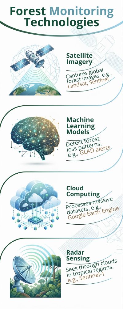
Key technologies behind A.I. forest monitoring
| Technology | What It Does | Example System |
|---|---|---|
| Satellite imagery | Captures global forest images | Landsat, Sentinel |
| Machine learning models | Detect forest loss patterns | GLAD alerts |
| Cloud computing | Processes massive datasets | Google Earth Engine |
| Radar sensing | Sees through clouds in tropical regions | Sentinel-1 |
Much of this is happening through platforms like Google Earth Engine, which processes satellite imagery at, as the company describes it, “a planetary scale.” Yes, that sounds hyperbolic. It isn’t.
The numbers behind the shift
A.I.-driven forest monitoring is not just a technology story, the statistics are also remarkable.
| Indicator | Value | Source |
|---|---|---|
| Global tree cover loss (2023) | 28.3 million hectares | Global Forest Watch |
| Primary tropical forest loss (2023) | 3.7 million hectares | World Resources Institute |
| Time needed to detect forest loss (traditional) | Months | FAO Forest Monitoring Reports |
| Time with AI alerts | 2–5 days | Global Forest Watch |
The F.A.O. Global Forest Resources Assessment notes that improvements in monitoring have dramatically shortened the time it takes to detect forest loss, particularly in the tropics, where deforestation can occur quickly and discreetly.
Speed is everything.
Illegal loggers can clear several hectares in a single night. If authorities receive alerts in days rather than months, suddenly they have a fighting chance of enforcement.
Algorithms acting like digital rangers
Some conservationists have taken to calling these monitoring systems “digital forest rangers.” That is not a bad description.
A.I. models are continuously comparing new satellite images with older ones. If the algorithms notice something suspicious, a patch of forest that has suddenly become lighter or more fragmented, for instance, they issue an alert.
The researchers behind the GLAD deforestation alert system estimate that their algorithms can detect disturbances as small as 0.1 hectares in some regions.
That is the equivalent of a small backyard.
When I first saw that statistic, I had to double check it. Forest monitoring used to be about clear-cuts big enough to be seen from space. Now we are talking about disturbances smaller than a football field. Technology has officially become an overachiever.
The human side of the story
Despite all the hype around algorithms, A.I. has not replaced humans in forest monitoring. Far from it. Local communities, field researchers and park rangers are still needed to verify alerts. In many cases, the satellite alerts simply help humans know where to look.
The best systems marry the two: the precision of machines with the judgment of humans. To be honest, that is a relief. Forest protection is probably not something that should be outsourced entirely to software developed by engineers who have spent more time with computers than with trees.
But if A.I. can help rangers get the job done faster, well, that is a very useful upgrade.
Satellites Watching Every Tree: Inside the Technology Tracking Earth’s Forests
At this very moment, there are satellites orbiting somewhere above your head. Whether you are sitting in a coffee shop in a busy city or a home office in a rural area, these satellites are silently circling above you. They don’t make a noise, they don’t ask permission, and they are taking pictures of the earth below them. Including forests.
The peculiar thing is that few people pay much attention to them.
Today, most of our forest monitoring is carried out by satellites. And when I say most, I mean a LOT. According to NASA’s Landsat program, Earth observation satellites are producing petabytes of data about the environment each year. That’s a mind-boggling amount of data. More than any human analyst can ever hope to review.
So if someone makes a throwaway comment like “satellites are watching the forest,” they’re not far off the mark. They really are.
Sometimes I think the earth must have its own CCTV system 700km up in the sky.
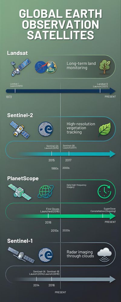
The Key Satellites for Forest Monitoring
Not all satellites are created equal. Some are designed for weather, some for urban mapping, others for ocean circulation. But a few of them have emerged as the go-to workhorses for monitoring forests.
| Satellite System | Agency | Key Function | Launch Period |
|---|---|---|---|
| Landsat | NASA / USGS | Long-term land monitoring | 1972–present |
| Sentinel-2 | European Space Agency | High-resolution vegetation tracking | 2015–present |
| PlanetScope | Planet Labs | Daily high-frequency imagery | 2016–present |
| Sentinel-1 | European Space Agency | Radar imaging through clouds | 2014–present |
A special mention is needed for the European Space Agency’s (ESA) fleet of Sentinel satellites. The Sentinel-2 satellites return to the same point on earth every five days, providing high-resolution images which can be used to assess changes in forest health, forest cover and even early signs of forest clearance.
Every five days doesn’t sound that impressive until you realise that forest surveys used to be carried out just once a year. Or less.
Change doesn’t always come with a bang. Sometimes it comes with better data.
The Problem of Tropical Forests
Monitoring forests from space sounds relatively straightforward. We just need to take pictures, right?
Unfortunately, it’s not that simple.
| Satellite System | Agency | Key Function | Launch Period |
|---|---|---|---|
| Landsat | NASA / USGS | Long-term land monitoring | 1972–present |
| Sentinel-2 | European Space Agency | High-resolution vegetation tracking | 2015–present |
| PlanetScope | Planet Labs | Daily high-frequency imagery | 2016–present |
| Sentinel-1 | European Space Agency | Radar imaging through clouds | 2014–present |
Tropical forests, such as those in the Amazon, Congo Basin or Southeast Asia are notoriously hard to monitor from space because of cloud cover. In some tropical regions, clouds obscure the forest for more than 200 days per year, according to the European Space Agency Earth Observation Programme.
That’s where radar satellites come in.
Unlike optical satellites, radar satellites such as Sentinel-1 beam microwave radiation down towards earth and then measure the reflections that return. Clouds, rain and even nightfall make little difference to radar instruments.
It’s a bit like giving satellites an X-ray vision for forests.
How Much Forest Data Are We Talking?
The scale of the forest data gets pretty breathtaking.
| Metric | Estimated Value | Source |
|---|---|---|
| Satellite images captured daily worldwide | ~1 million | USGS Earth Resources Observation and Science Center |
| Landsat archive size | Over 50 years of data | NASA Landsat Archive |
| Average satellite revisit time (modern constellations) | 1–5 days | European Space Agency |
| Global forest area monitored | ~4.06 billion hectares | FAO Global Forest Resources Assessment |
Four billion hectares of forest. That’s what the satellites are trying to monitor.
When I first saw that figure in the FAO Global Forest Resources Assessment, I had to stop for a moment. Obviously, it’s impossible to monitor every single tree. But satellites can monitor patterns. They can track changes in canopy density, colour or the emergence of clearings which tell us a broader story about the forest.
From Images to Insights
Satellite images alone won’t save forests. They’re just images.
The insights come when those images are processed, compared and analysed using platforms such as Google Earth Engine or Global Forest Watch.
Here’s the clever bit. Computer algorithms compare images captured days or weeks apart to detect subtle changes in forest cover. If a new clearing appears, perhaps a road slicing through previously dense forest, the algorithm will flag it up for further investigation.
Is it logging? Is it agriculture? Is it mining?
That’s where humans come in to take a closer look.
While technology may be the first to spot change in a forest, it’s still people who have the story to tell about why that change happened. And to be frank, I think that combination of satellites and humans is probably the only way we’re going to monitor something as vast and complex as the world’s forests.
How Machine Learning Detects Illegal Logging in Real Time
But the logging mafia has one big advantage. A team of chain saw-armed men can cut down several hectares of forest in a single night, load the wood onto trucks and drive off into the darkness before anyone even notices. For a long time, that was the crux of the problem. By the time anyone realized what had happened, the forest was gone. The machines have changed this tempo.
Rather than waiting months for reports from local communities or carrying out their own forest surveys, AI programs scan new satellite images almost continuously to track any changes in forest cover. When they find something unusual, a patch of forest that has disappeared, a new dirt road or an odd geometric shape, they send an alert.
Many of these alerts are generated by AI systems developed by the GLAD deforestation monitoring system at the University of Maryland Global Land Analysis and Discovery Lab. Their AI models process satellite images from NASA’s Landsat satellites and issue forest disturbance alerts about once a week.
A weekly alert doesn’t sound very rapid, but compared with the three- to 12-month cycles that previously dominated the monitoring process, it’s lightning quick.
Training a Computer to “See” a Tree
The AI models aren’t actually able to “see” a forest in the way a human sees it. Instead, they search for anomalies in data, changes in color, light, texture. To a computer, a forest is just a complex grid of numbers. To train the AI, researchers feed it historical images of deforested areas.
The AI is shown thousands of examples of clear-cut forests, logging roads, burn marks and damaged canopies. It learns the telltale signs of forest destruction. If this sounds a bit like training a dog to sniff out a scent, that is not a bad comparison.
According to Global Forest Watch data, AI-enabled monitoring systems now track more than 4 billion hectares of forest around the world and issue millions of alerts a year signaling possible tree cover loss.
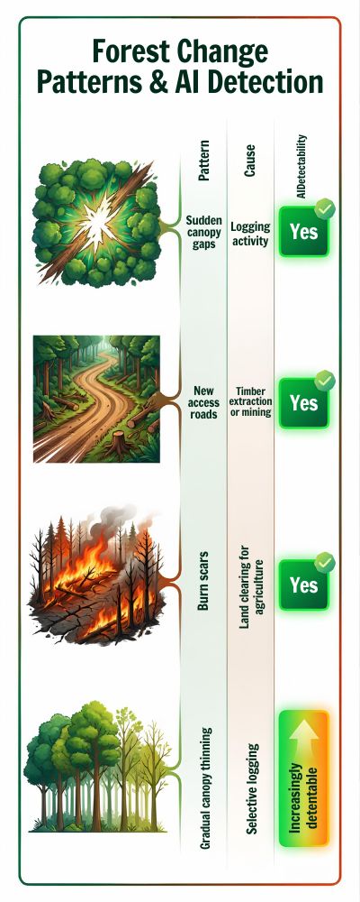
What the AI is Actually Looking For
Not all forest disturbances are easy to spot. Selective loggers may remove only a few trees at a time, leaving much of the forest canopy intact.
| Forest Change Pattern | Possible Cause | Detectable by AI |
|---|---|---|
| Sudden canopy gaps | Logging activity | Yes |
| New access roads | Timber extraction or mining | Yes |
| Burn scars | Land clearing for agriculture | Yes |
| Gradual canopy thinning | Selective logging | Increasingly detectable |
This is where AI really proves its worth. According to the World Resources Institute, some AI models can now spot disturbances as small as 0.1 hectares in size, depending on the resolution of the satellite images and the density of the forest.
That’s about the area of a tennis court.
A decade ago, that level of precision would have sounded nearly unimaginable.
Cloud computing also plays a critical role in all of this.
Processing individual satellite images is a massive undertaking. Each single Landsat scene contains millions of pixels. And thousands of scenes are captured every day. It’s a computational headache. Cloud-based platforms like Google Earth Engine allow researchers to store and process enormous environmental data sets in the cloud.
This means researchers can run AI models across decades’ worth of satellite images in a matter of hours, rather than weeks. Cloud computing is really the only reason that near real-time monitoring is possible at all.
The AI Alert is Just the Start
One thing that tends to get lost in conversations about AI and deforestation is that an AI alert is not the same thing as proof of illegal logging. It’s just proof that the forest has changed in some way. Local officials, NGOs or other conservation groups still have to investigate to determine what caused the change. Sometimes it’s legal logging or the result of a forest fire or severe weather event.
Sometimes it’s evidence of a large-scale illegal logging operation. The Food and Agriculture Organization of the United Nations estimates that between 15 and 30 percent of the world’s timber is harvested illegally, costing governments billions in lost revenue and fueling forest degradation.
When an AI model detects suspicious activity rapidly, it gives officials something they rarely have: time. In the battle against illegal logging, time is everything.
The Amazon, Congo and Southeast Asia: Where Forest Loss Is Accelerating
If you’ve read a recent article about deforestation, it probably included one of three locations: The Amazon Basin, the Congo Basin or Southeast Asia. The three regions are home to the last remaining large blocks of tropical forest, and most of today’s deforestation takes place there.
It’s easy to become desensitized by the scale of the deforestation data. In 2023, the world lost approximately 28.3 million hectares (69.6 million acres) of tree cover, according to Global Forest Watch data. That’s roughly the area of Italy that just vanished. The first time you see that number, it seems abstract, like something too big to really grasp.
But if you take a moment to think about it, as entire landscapes are being erased every 12 months, it doesn’t seem so abstract. A subject that often gets a little lost in the general reporting is that deforestation unfolds differently in different places.
The drivers of forest loss in Brazil are not the same as those in the Congo Basin or Indonesia. Every country has its own economics, politics and ground-level realities. So let’s take a closer look at the top three.
Amazon Rainforest
The Amazon Rainforest is the big daddy. At almost 6.7 million square kilometres (2.6 million square miles), it spans nine South American countries, mostly in Brazil. What happens in the capital, Brasília, has an outsized impact on the forest. In 2023, more than 9,000 square kilometres of the Amazon Rainforest were cleared, according to Brazil’s National Institute for Space Research (INPE).
Most of the deforestation is for agriculture. Beef and soy are the main offenders, and they’re deeply intertwined with international trade. Both are valuable commodities, and demand for them is growing everywhere. There is always incentive to clear more land. Sometimes it’s forest.
| Amazon Snapshot | Data |
|---|---|
| Total rainforest area | ~6.7 million km² |
| Countries sharing the forest | 9 |
| Major drivers | Cattle ranching, soy farming, mining |
| Annual deforestation alerts | Millions (satellite detected) |
Scientists at the World Resources Institute (WRI) say that if deforestation reaches 20-25% of the original Amazon, the ecosystem will collapse. That means huge sections of the rainforest will begin to shift toward a more savanna-like ecosystem. Scientists don’t bandy about that kind of statement lightly. Once the shift starts, it will be nearly impossible to stop.
Congo Basin
The Congo Basin gets relatively little international press compared to the Amazon, even though it is massive. It’s the second-largest tropical rainforest in the world, encompassing nearly 2 million square kilometres (772,000 square miles) and stretching across six Central African countries. Despite the massive remaining forests, there are signs of concern.
According to data from the Central African Forest Observatory and the FAO Global Forest Resources Assessment, deforestation in the region is rising. It’s not as rapid as in some other places, but it’s moving in the wrong direction. The underlying causes are familiar. They include logging, mining and small-scale farming.
| Congo Basin Snapshot | Data |
|---|---|
| Forest area | ~3.7 million km² |
| Major countries | DR Congo, Cameroon, Gabon |
| Key drivers | Logging, subsistence farming |
| Carbon storage | Billions of tons |
For many people in these areas, forests are their livelihood. Forests supply food, fuel and income. That’s an aspect of deforestation that those of us far from the tropical forests can easily forget. Overall, scientists say there is more “visible” deforestation in the Amazon and Southeast Asia than in the Congo Basin.
In fact, scientists have referred to the deforestation situation in the Congo Basin as a “slow-burning crisis.” You don’t see as many front-page stories about deforestation in the Congo Basin. You don’t see as many dramatic before-and-after photos of deforestation. The deforestation that is happening in the Congo Basin has been occurring slowly over the years.
Climate scientists have referred to the Congo Basin as a “sleeping giant” because it contains so much carbon but has gotten relatively little attention in climate negotiations. There’s a sense that the world may not fully appreciate the value of the Congo Basin until it is too late.
Southeast Asia
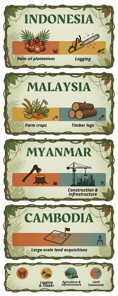
The situation is a bit different in Southeast Asia, where deforestation has been occurring more rapidly over the past several decades. Indonesia and Malaysia, for example, still have plenty of tropical forest, but they’ve also been the site of some of the highest rates of deforestation over the last few decades.
Much of this deforestation has been driven by the expansion of palm plantations as well as by logging and infrastructure development. According to the UN’s Food and Agriculture Organization (FAO), the region has lost tens of millions of hectares of forest since the early 1990s. It’s worth noting that the situation in Southeast Asia isn’t all doom and gloom.
| Country | Main Causes of Forest Loss |
|---|---|
| Indonesia | Palm oil expansion |
| Malaysia | Timber and agriculture |
| Myanmar | Logging, development |
| Cambodia | Land concessions |
Some of the region’s countries have been able to slow deforestation in recent years by enacting better forest protections and land-use policies. But one factor that consistently appears in the data is roads.
When roads are built into previously remote forested areas, other activities soon follow, including logging, farming, and settlement. Satellites that track forest health now see signs of disturbance in these forests almost every day.
Sometimes analysts can see the process play out nearly in real-time: A road gets built, a few clearings appear, and then suddenly a giant chunk of forest is gone. It’s a familiar pattern to many forest researchers. Roads lead to forests. Forests lead to development. And development rarely politely stops at the treeline.
What Can We Do?
All of this deforestation in these regions is more than just a tree issue. Tropical forests are home to some of the highest levels of biodiversity on the planet, and they store massive amounts of carbon. When forests are burned or cut down, all of that carbon gets released into the atmosphere, contributing directly to climate change.
Around the world, agriculture is still the biggest driver of deforestation. Satellite technology has made it possible to track deforestation at a remarkable level of detail. With the help of satellites and artificial intelligence, researchers can now get nearly real-time alerts when forests are being cleared. But satellites can only tell us so much. They can tell us where forests are being destroyed.
The trickier part, the part that governments, businesses, and consumers are still trying to figure out, is why deforestation keeps happening and what trade-offs societies are willing to make to slow it down. And that discussion, no matter how uncomfortable it may be, might be more important than any satellite photo.
From Months to Minutes: Why AI Is Transforming Deforestation Detection
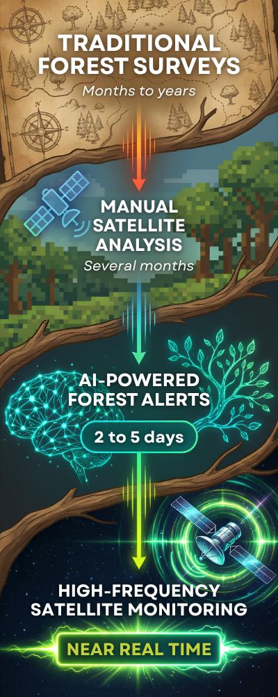
Not so long ago, the way to monitor forest loss was agonizingly slow. Scientists would take a set of satellite images and then compare them, later publishing their results six months or even a year after deforestation had taken place.
By the time a study had been published, the chainsaws were already gone, and the forest clearing was already complete.
The Food and Agriculture Organization (FAO) has estimated that national forest monitoring was typically based on either annual surveys or retrospective analysis of satellite imagery. In other words, it was hard to battle illegal deforestation if you were looking backward. That time delay was, for a while, one of the biggest vulnerabilities in forest conservation.
The AI Turning Point
That all started to change when machine learning algorithms began comparing satellite images. Rather than having humans visually scan hundreds of thousands of images, new images were compared to previous ones instantaneously.
Initiatives such as Global Forest Watch and the GLAD Lab at the University of Maryland’s Department of Geographical Sciences began building systems that could identify changes in forest cover just days after they happened.
Sometimes even sooner.
With AI, in other words, something that once took months now takes hours or minutes, depending on how quickly data is processed. Imagine going from sending a handwritten letter to sending an instant message. It’s basically the same thing, but on entirely different time scales.
The Before and After
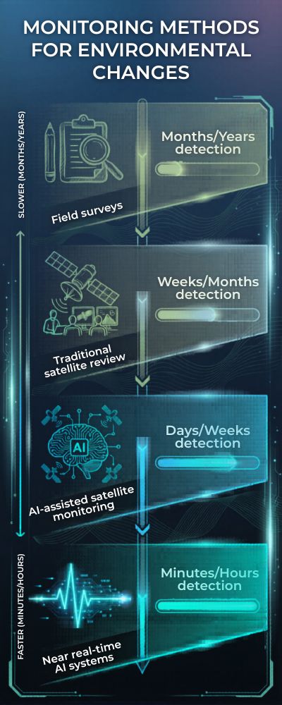
Comparing the old monitoring approach to the new AI-powered monitoring approach is pretty remarkable.
| Monitoring Method | Typical Detection Time | Data Processing |
|---|---|---|
| Field surveys | Months to years | Manual |
| Traditional satellite review | Several months | Human interpretation |
| AI-assisted satellite monitoring | 2–5 days | Automated analysis |
| Near real-time AI systems | Minutes to hours | Continuous algorithms |
The GLAD deforestation alert system used by conservationists generates weekly forest disturbance alerts for the tropics, based on satellite analysis from NASA’s Landsat satellites.
And that timing difference is a big deal.
Deforestation often occurs rapidly. Sometimes illegal logging operations will clear an area in a matter of days. If alerted in time, authorities can now visit a site while activities are ongoing rather than after the fact.
Analyzing All the World’s Data
This is where things get a bit mind-boggling: Earth observation satellites generate millions of images every day.
According to the U.S. Geological Survey’s Earth Resources Observation and Science Center, today’s Earth-monitoring satellites return millions of images a year, covering everything from forests to oceans to cities.
Without AI and cloud computing, much of that data would never be analyzed.
Tools like Google Earth Engine enable scientists to process petabytes of satellite imagery, analyzing decades of data using machine learning algorithms.
It’s the sort of computational capability that would have sounded like science fiction 20 years ago.
A New Era of Forest Monitoring
The end result of all that analysis is something conservationists now call near real-time forest monitoring.
When satellites spot potential tree cover loss, alerts are automatically sent to governments, NGOs, and local communities that can access them almost as soon as they’re available.
| AI Monitoring Benefit | Impact |
|---|---|
| Faster alerts | Illegal logging can be detected earlier |
| Wider coverage | Billions of hectares monitored globally |
| Greater transparency | Public data access improves accountability |
| Better enforcement | Authorities can respond more quickly |
Today, Global Forest Watch’s monitoring systems cover more than 4 billion hectares of forest worldwide, sending alerts to researchers, journalists, and governments who are now able to track deforestation in something approaching real time.
And to be honest, that capability shift, from slow to near real time, strikes me as one of the most underappreciated technology trends in the environmental arena.
The forest still faces plenty of threats, of course. But at least now, when the trees begin to fall, someone somewhere is going to notice a lot sooner than they used to.
The Data Behind Climate Protection: Why Forest Monitoring Matters for Net-Zero Goals
![]()
Climate change is often discussed in terms of solar panels and electric cars. Not so much forests. Trees just hum along in the background, absorbing CO2 day in and day out without much fanfare.
And they’re really good at it. According to the Intergovernmental Panel on Climate Change (IPCC) , the world’s forests suck up around 7.6 billion tonnes of CO2 annually, removing about a third of the CO2 generated from burning fossil fuels.
That’s not insignificant. When we lose forests, we not only destroy an ecosystem and a habitat, but also a massive carbon sink. It’s like taking the brakes off a careening car and wondering why it won’t slow down.
So, why do forests matter to “net-zero?” Many countries and companies have pledged “net-zero emissions.” In theory, the concept is straightforward: any greenhouse gases emitted are balanced by the amount of greenhouse gases taken out of the atmosphere. The problem? You can’t manage what you can’t measure. That’s where forest monitoring comes in.
By measuring the amount of forest cover, biomass and carbon storage, governments can estimate how much carbon forests are absorbing. The Food and Agriculture Organization’s (FAO) Global Forest Resources Assessment estimates that there are currently around 4.06 billion hectares of forest remaining, covering about 31% of the Earth’s surface.
| Forest Climate Metric | Estimated Value | Source |
|---|---|---|
| Global forest area | ~4.06 billion hectares | FAO |
| Annual CO₂ absorbed by forests | ~7.6 billion tonnes | IPCC |
| Share of global emissions offset | ~30% | IPCC |
| Annual global tree cover loss (2023) | 28.3 million hectares | Global Forest Watch |
But the world’s forests are constantly growing, shrinking, recovering and degrading. Without systems in place to monitor this, climate models are simply guessing.
Tree cover loss in 2023 according to Global Forest Watch data. Global Forest Watch data shows that 28.3 million hectares of tree cover was lost last year alone, much of it in the tropics. When forests are cleared or burned, the carbon stored in the trees isn’t destroyed, it simply returns to the atmosphere. Not exactly what net-zero strategies are aiming for.
Satellites and Algorithms for Climate Accountability
Much of today’s forest monitoring relies on satellite technology and machine learning algorithms. NASA’s Landsat Earth observation system and the European Space Agency’s (ESA) Copernicus Sentinel satellites monitor forests on a regular basis. Why does that matter? Countries are becoming increasingly accountable for their climate commitments based on measurable land use changes.
The data countries submit to report their progress toward the Paris Climate Agreement, for example, rely on forest monitoring to estimate carbon sinks. Without that, countries would be keeping track of their climate “bank account” without monitoring its balance.
Monitoring Forests Is Also a Matter of Trust
There’s another important reason to monitor forests: accountability. Governments, companies and even carbon offset markets claim to reduce greenhouse gas emissions by protecting or restoring forests. Satellite monitoring helps ensure that those reductions are real.
| Monitoring Tool | What It Tracks |
|---|---|
| Satellite imagery | Forest cover change |
| AI detection systems | Logging and land clearing |
| Carbon mapping models | Biomass and carbon storage |
| Open data platforms | Public accountability |
Platforms such as Global Forest Watch make near-real-time forest data available to journalists, scientists and policy makers. That transparency is crucial, as climate targets are only as good as the data that supports them.
The Bigger Picture
Forests won’t single-handedly stem the climate crisis. Clearly, they won’t. Fossil fuel emissions dominate the global carbon balance.
But forests are among the most effective natural solutions we have.
By protecting forests, and knowing exactly what is happening to them, we can give policymakers, scientists and communities a shot at meeting net-zero climate goals.
And if the world is committed to meeting its climate targets, monitoring forests isn’t just a good idea, it’s necessary.
The Accuracy Question: How Reliable Are AI-Driven Forest Monitoring Systems?
You see it on the news. You hear it on social media. You read it in reports and articles. Artificial intelligence, AI, is being used to monitor and protect forests. But, is it any good? AI-powered forest monitoring is powerful. It’s new. It’s the kind of thing that you would expect to see in some futuristic movie. But it’s real.
However, there are many people wondering just how accurate it is. Governments and conservationists are using AI-powered monitoring to detect deforestation. They receive alerts and then go and investigate. If the AI is faulty and the alerts are wrong, it can be a wild goose chase.
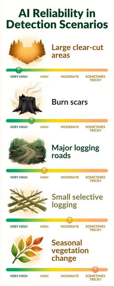
Researchers from the University of Maryland’s Global Land Analysis and Discovery (GLAD) Lab say that some satellite-based forest loss detection systems can have accuracy rates of over 90 percent when detecting large-scale deforestation using Landsat data. That’s a very good score. However, it’s not perfect.
What the AI does well
AI is very good at detecting large-scale deforestation. If someone cuts down a big patch of trees, the satellites will pick it up and the AI will detect it. The AI used for forest monitoring is based on comparing current satellite images to past images of the same area to detect sudden changes in the forest canopy.
| Detection Scenario | AI Reliability |
|---|---|
| Large clear-cut areas | Very high |
| Burn scars | High |
| Major logging roads | High |
| Small selective logging | Moderate |
| Seasonal vegetation change | Sometimes tricky |
According to research by the NASA Landsat Science Program, decades of archived satellite data are being used to train machine learning algorithms to recognize common forest disturbance patterns. Therefore, when a large area of forest is cleared, the AI can recognize it and sound an alert. Unfortunately, it’s not that simple.
The not-so-good news
Forests and natural environments are complex. The foliage changes with the seasons. Trees and plants dry out and die. Storms damage trees. Sometimes the AI thinks someone is cutting down trees when in fact, it’s just a natural fluctuation. These are known as false positives and can be one of the major drawbacks of the system. Clouds can also be a problem, particularly in tropical regions.
The European Space Agency’s Copernicus Sentinel Program says that high cloud coverage can obscure the optical data in some regions for a significant part of the year. That’s why radar missions like Sentinel-1 are being used in conjunction with optical missions. Radar can penetrate clouds and provide data where optical images are not available. However, it’s still not perfect.
The balance between speed and accuracy
There’s a balance between speed and accuracy that researchers talk about a lot. AI alerts can detect potential forest loss within days, but those alerts need to be verified before any action can be taken.
| Monitoring Stage | Who Handles It |
|---|---|
| Satellite detection | AI systems |
| Alert generation | Automated algorithms |
| Verification | Human analysts |
| Field confirmation | Local authorities or NGOs |
The World Resources Institute says that combining machine learning-powered detection with human evaluation greatly increases the accuracy of the alerts. In other words, the AI identifies potential problems, but humans still need to verify them.
Humans are still essential
Despite the hype about AI, forest monitoring is still not automatic. Far from it. Local communities, scientists, and enforcement agencies still play an important role in verifying alerts and assessing what’s happening on the ground. And that’s the way it should be. AI can process satellite data and identify patterns faster and more efficiently than any human.
However, a forest is not a collection of pixels on a screen. It’s a dynamic ecosystem that includes weather, animals, humans, and unpredictable events. The best forest monitoring systems involve AI sifting through the data and identifying potential problems and humans verifying and investigating those alerts.
It may not be entirely science fiction, but it’s still a giant leap forward from where forest monitoring was 10 years ago.
Governments vs Illegal Logging: How Real-Time Forest Alerts Are Changing Enforcement
Illegal logging used to be infuriatingly hard to prosecute. This wasn’t because nobody cared. It was just that by the time authorities noticed, it was too late. Very late. Somebody would chop down trees somewhere deep in the Amazon or Southeast Asia. Weeks, even months would pass before anyone realized what was happening.
By the time the satellite images were analyzed and reports were filed, the timber would already be on trucks or boats on its way somewhere else. Game over. Estimates by the World Bank suggest that illegal logging still accounts for 10 to 30% of the global timber trade. This comes out to billions of dollars in lost revenue every year. Not to mention the environmental cost.
For a long time, this was the state of affairs: Loggers acted fast, while justice plodded along at the speed of bureaucracy. Not much of a contest, really.
The Day Forest Monitoring Got an Upgrade
This all changed once satellite monitoring systems were combined with machine learning. Rather than having analysts manually review satellite images for signs of disturbance, algorithms could do the initial pass automatically.
Platforms like Global Forest Watch and monitoring tools developed by the University of Maryland GLAD Lab would compare new satellite images to previous ones and alert any sudden changes in forest cover.
If a patch of forest suddenly went missing, the system would send an alert. Sometimes in a matter of days. Now, this doesn’t sound earth-shattering at first blush, but the difference between months and days makes all the difference in enforcement.
| Monitoring Method | How Long Detection Takes |
|---|---|
| Traditional forest surveys | Months or longer |
| Manual satellite analysis | Several months |
| AI-based forest alerts | 2–5 days |
| High-frequency satellite monitoring | Sometimes faster |
In short: Authorities now have a chance to catch illegal activity while it’s still happening. And that’s a big deal.
Governments Are Finally Getting Eyes on the Forest in Real Time
Some governments have started using these alerts in their enforcement activities. Brazil, for example, makes heavy use of monitoring systems developed by the Brazilian National Institute for Space Research (INPE). One of their programs, called DETER, produces near real-time alerts that help environmental agencies monitor suspicious forest clearing in the Amazon.
This isn’t a silver bullet.
It doesn’t end deforestation today.
But it gives investigators a lead. Organizations like the World Resources Institute have also pushed for greater transparency by making forest alert data publicly available. This means that journalists, NGOs and even local communities can monitor where forest loss is occurring almost as it happens.
And once data is public, it’s much harder to turn a blind eye.
What These Alerts Actually Show
So how do these monitoring systems actually work? Behind the scenes, they do something fairly simple but remarkably powerful: They compare images over time. When something changes quickly, like a new clearing or a road slicing through previously intact forest, the system flags it.
| Alert Signal | What It Might Mean |
|---|---|
| Sudden tree cover loss | Possible logging |
| New road construction | Access route for timber extraction |
| Burn scars | Land clearing for agriculture |
| Forest degradation patterns | Selective logging |
Except that an alert isn’t a certainty of a crime. It could be legal deforestation or something naturally occurring.
But it tells the authorities where to look. And that’s often the hardest part.
Boots on the Ground Still Matter
Satellites can identify a suspect clearing, but you still need someone to go out there and check what’s really going on.
And here’s where the problem comes in.
Many of the countries with big forests don’t have the resources to employ enough enforcement staff to patrol their millions of hectares of wilderness. According to the Food and Agriculture Organization, resource shortages remain one of the biggest challenges in combating illegal logging worldwide.
A satellite can identify a clearing in seconds.
It might still take days to get a ranger there.
A Slight Shift in the Balance
And yet, even with all of that, something has shifted.
For a long time, the power of illegal logging was the fact that forests are enormous and far away. The assumption was simple: nobody is watching.
That assumption doesn’t stand up quite as well these days.
With satellites beaming back data on the planet all the time, and AI systems picking up anomalies, forests aren’t nearly as invisible as they once were.
Does that stop illegal logging in its tracks? No.
But it does make the game a little riskier for those trying to operate under the radar. And in a battle that has historically been very one-sided, any shift in the balance is a good thing.
Open Data and Transparency: The New Era of Global Forest Intelligence
Not so very long ago, if you were looking for information on deforestation, you had to dig for it. And not in a fun way. Government reports and academic papers and scattered satellite images and databases that only a select few knew how to access.
If you were a journalist or researcher or concerned member of the public looking for data on forest loss, you might feel like you were trying to read a map with half the pieces torn out. That has all changed in the last ten years. Now, an astonishing amount of data on forests is available online.
With a laptop and a decent internet connection, you can explore satellite imagery, track forest loss, and receive alerts of deforestation in almost real time. And, really, the move to open data may be one of the most under-appreciated advancements in environmental science.
The Rise of Open Forest Monitoring Platforms
Much of that shift can be attributed to platforms like Global Forest Watch, which was developed by the World Resources Institute and a consortium of research partners.
The platform combines satellite imagery, machine learning algorithms, and open data to monitor forest change around the world.
Users can zoom in on almost any forest and see where tree cover has disappeared over time.
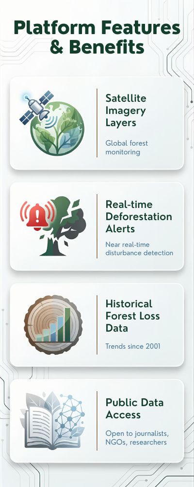
| Platform Feature | What It Provides |
|---|---|
| Satellite imagery layers | Global forest monitoring |
| Real-time deforestation alerts | Near real-time disturbance detection |
| Historical forest loss data | Trends since 2001 |
| Public data access | Open to journalists, NGOs, researchers |
According to the FAO Global Forest Resources Assessment, there are still some 4.06 billion hectares of forest remaining, which cover about 31% of the Earth’s land area.
That is a lot of ground to cover. And it requires a lot of data. And a lot of transparency.
A New Level of Accountability
Open forest data has also meant that it is possible to hold governments and companies accountable for their environmental pledges. Many companies now tout “deforestation-free supply chains.” National climate commitments include provisions to curb land-use emissions. But those pledges mean little without monitoring to back them up.
That is where open forest monitoring platforms come in. Scientists and journalists and advocacy groups can check a company or country’s claims against the satellite record. And when deforestation spikes in a supposedly protected area or inside a supply chain, someone is likely to notice. And when that happens, uncomfortable questions tend to follow.
| Data Source | What It Tracks |
|---|---|
| Landsat satellites | Long-term forest change |
| Sentinel satellites | High-frequency vegetation monitoring |
| Global Forest Watch | Public forest alerts |
| FAO Forest Resources Assessment | Global forest statistics |
The Bigger Picture
Of course, open data is no panacea. Forest protection ultimately depends on politics and policy and economics.
But transparency matters.
When data on forest loss is available to everyone and not just a select few, it becomes that much harder for bad actors to hide their activities.
In a way, forests are not so remote as they once were. They are being monitored, not just by satellites, but by scientists and journalists and advocates and anyone who is simply curious enough to poke around on a map.
And that is potentially one of the most powerful conservation tools of all.
The Next Frontier: AI, Drones and Sensor Networks for Forest Protection
![]()
We already know how satellite monitoring is transforming forest monitoring. But what about the role of other technologies? Could AI-equipped drones, acoustic sensors and sensor networks also be changing forest protection? The answer is yes. It’s a bit like moving from a CCTV camera to a full alarm system.
Satellites still offer the broad overview, taking in vast expanses of forest. Newer technologies offer more detail on what’s going on at forest floor level. And they can detect some things that satellites simply can’t.
Drones: The Forest Rangers That Fly
Drones are increasingly being used by NGOs and environmental authorities to monitor forests that are hard to reach. Unlike satellites, drones can fly below the forest canopy, take incredibly high-definition images and can be deployed at short notice.
According to the United Nations Environment Programme, conservation drones are now being used in dozens of protected areas around the world to monitor illegal logging, poaching and deforestation.
The advantages are obvious.
A drone can access places where a car can’t and where it might take hours or even days to send in a team of rangers.
| Drone Monitoring Feature | Benefit |
|---|---|
| High-resolution imagery | Detailed forest damage detection |
| Rapid deployment | Immediate response to alerts |
| Low-altitude monitoring | Detects small-scale logging |
| Thermal cameras | Night monitoring capability |
Some drones are equipped with AI technology that can automatically recognize clearings and disturbance in the forest, or signs of activity like smoke, in the images they capture. It’s not quite the monitoring grid from a sci-fi movie, but it’s closer than you might think.
Listening to the Forest
Acoustic sensor networks are one of the most intriguing technologies in development for forest monitoring. Instead of viewing the forest, they listen to it.
Projects like Rainforest Connection use solar-powered audio recorders hung in the forest canopy to record the sounds of the forest.
Why listen?
Well, chainsaws are noisy.
Machine learning algorithms can analyze the audio recordings and pick out the audio signature of a chainsaw, a truck engine or a gunshot. If the system recognizes something suspicious, it can send a signal to conservation teams in the area. Together, these systems create something that didn’t exist a decade ago: a multi-layered monitoring network that watches forests from space, sky and ground.
| Acoustic Signal | Possible Event |
|---|---|
| Chainsaw noise | Illegal logging |
| Engine sounds | Vehicle intrusion |
| Gunshots | Possible poaching activity |
| Wildlife calls | Biodiversity monitoring |
Technology Is Only Part of the Story
It’s worth noting that technology isn’t a silver bullet for forest protection. Drones and sensors can identify illegal activity, but there still has to be a response to that information. Many forested areas remain extremely remote, and law enforcement capacity is limited.
According to the Food and Agriculture Organization, effective forest protection still relies heavily on local governance, community support and political will. Technology can level the playing field. But forests are still protected not by machines, but by people willing to defend them.
Forest Monitoring in 2030: What the Future of AI-Powered Conservation Might Look Like
Imagine yourself standing in a rainforest in 2030. Above the treetops, satellites are circling the Earth. A drone buzzes by to take a snapshot. Pressure sensors in the trunks are listening for the sound of chainsaws. And an artificial intelligence algorithm, sitting on a server somewhere, is taking all this data and asking a simple question: has something changed here?
That sounds like science fiction, but some of this is already happening.
What will change in the next decade is the speed, scale, and brains of these monitoring systems.
The European Space Agency’s Earth Observation Programme estimates that the number of Earth-observation satellites circling our planet will balloon by 2030, radically increasing how often forests can be viewed from space.
More satellites means fewer blind spots.
The Rise of Continuous Forest Monitoring
Most forest monitoring these days is done with satellites that pass over the same spot every few days. By 2030, that time between visits could shrink even more.
Companies like Planet Labs already have constellations capable of imaging much of the planet on a daily basis, and scientists expect that to get even more frequent as new satellites launch.
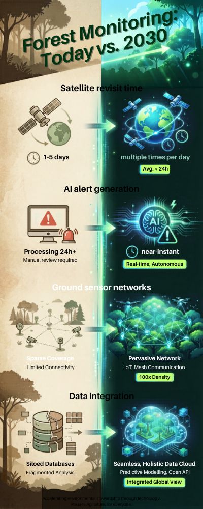
| Monitoring Capability | Today | Possible by 2030 |
|---|---|---|
| Satellite revisit time | 1–5 days | Multiple times per day |
| AI alert generation | Hours to days | Near instant |
| Ground sensor networks | Limited | Widespread in protected forests |
| Data integration | Partial | Fully automated systems |
The result could be something approaching continuous monitoring, where disturbances are detected almost immediately.
Which, if you think about it, changes the psychology of illegal logging quite a bit. It’s harder to sneak around when the forest has eyes everywhere.
AI Will Move From Detection to Prediction
Right now, most AI-powered monitoring tools are designed to detect deforestation after it starts. But researchers are already tinkering with algorithms that predict where forest loss might occur next.
The concept is surprisingly simple: look at the patterns of the past, including new roads, agricultural expansion, land prices, and population growth, and identify areas at high risk.
Scientists at the World Resources Institute and Global Forest Watch are already using machine learning algorithms to forecast potential deforestation hotspots.
| AI Function | What It Could Do by 2030 |
|---|---|
| Risk prediction | Identify likely deforestation zones |
| Carbon tracking | Measure forest carbon changes in real time |
| Biodiversity monitoring | Track habitat changes automatically |
| Policy evaluation | Measure conservation impact quickly |
In other words, AI may go from detecting forest loss to preventing it. That would be a major step.
Forest Data Will Become More Public
The other big shift coming by 2030 is the growth in open environmental data.
Platforms like Global Forest Watch have already democratized access to satellite-based forest monitoring, meaning anyone with an internet connection can access timely information on deforestation. Whether you are a journalist, researcher, policymaker or a student with a curious eye, anyone can explore patterns in deforestation.
And this matters.
When environmental data is open, it is much harder for governments or companies to turn a blind eye to forest loss.
Technology Is Powerful… But Not the Whole Story
Even the most sophisticated monitoring approaches will not save the world’s forests. Satellites can identify forest loss. AI can alert to suspicious activities. Drones can capture images of what is happening on the ground.
But none of them can make policy decisions.
According to the Food and Agriculture Organization, the world still has 4.06 billion hectares of forest covering about 31 percent of the planet’s land area. Saving those forests will still come down to policy, economic incentives and local communities determined to protect them.
Technology can help. A lot.
But the future of the world’s forests will not be determined by an algorithm. It will be determined by people and how seriously they choose to act on the information an algorithm provides.
When you step back and look at the big picture, the story of forest monitoring in the modern age isn’t really about technology at all. Satellites, AI models, drones, sensor networks, they are all incredibly powerful tools, of course. But tools are only as useful as the purposes to which they are put.
The really hard work still lies ahead, with governments and corporations and consumers making decisions about what value to place on a forest. Technology can tell us where the forest is vanishing, often almost in real-time. It can sniff out illegal logging, uncover patterns of land clearance, and apply a modicum of pressure to those in positions of power to behave better than they otherwise might.
But it can’t make the hard decisions for us. That’s still up to humans. And perhaps that’s the underlying message that runs quietly through all of this: We now have better data on the state of the world’s forests than we have ever had before. The question is whether we are prepared to act on it.
Sources
Global Forest Watch – Forest Monitoring Data and Deforestation Alerts
https://www.globalforestwatch.orgWorld Resources Institute (WRI) – Global Forest Monitoring and Climate Research
https://www.wri.orgNASA Landsat Earth Observation Program – Satellite Monitoring of Earth’s Surface
https://landsat.gsfc.nasa.govEuropean Space Agency Copernicus Sentinel Satellites – Earth Observation Program
https://sentinels.copernicus.euEuropean Space Agency Earth Observation Programme
https://earth.esa.intFAO Global Forest Resources Assessment – Global Forest Statistics
https://www.fao.org/forest-resources-assessmentIntergovernmental Panel on Climate Change (IPCC) – Climate and Carbon Cycle Research
https://www.ipcc.chUniversity of Maryland Global Land Analysis and Discovery (GLAD) Lab – Forest Monitoring Research
https://glad.umd.eduGoogle Earth Engine – Planetary Scale Environmental Data Analysis Platform
https://earthengine.google.comBrazilian National Institute for Space Research (INPE) – Amazon Deforestation Monitoring
https://www.gov.br/inpeCentral African Forest Observatory (OFAC/COMIFAC) – Congo Basin Forest Data
https://www.observatoire-comifac.netPlanet Labs – High-Frequency Satellite Earth Observation
https://www.planet.comRainforest Connection – Acoustic Monitoring for Forest Protection
https://rfcx.orgUnited Nations Environment Programme (UNEP) – Environmental Monitoring Technologies
https://www.unep.orgWorld Bank – Global Forestry and Illegal Logging Statistics
https://www.worldbank.org/en/topic/forestsUSGS Earth Resources Observation and Science (EROS) Center – Satellite Data Archive
https://www.usgs.gov/centers/erosUNFCCC – The Paris Climate Agreement and Climate Policy Framework
https://unfccc.int/process-and-meetings/the-paris-agreement